5° at the start, cloudy and grey · Light rain mid-morning · Headwind out, tailwind home
I. Wrong Turn
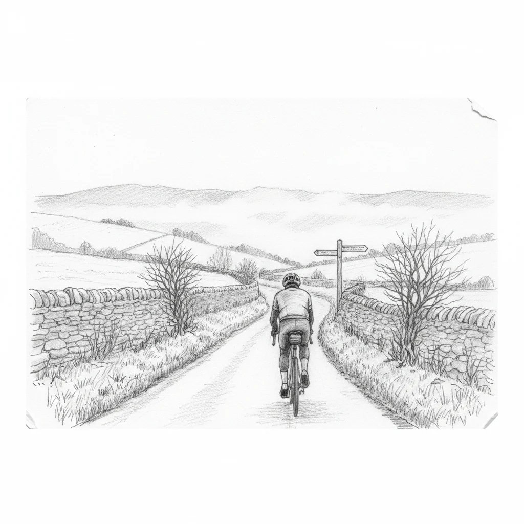
Good Friday morning. Eight forty-four, and the sky is the colour of an old wool blanket — low, grey, the kind of English April that makes you check the forecast twice and go anyway. It is chilly enough for long fingers and a wind that finds the gaps in your jersey, but the bike is packed up and the legs need work. In two months I will be cycling seven hundred kilometres across Burundi, and the hills of East Africa will not care whether I trained in sunshine or in drizzle. So we go.
One mile from home and I have made my first wrong turn. This is not an auspicious start. I have my Beeline Velo 2 — a little circular satnav clipped to the handlebars, linked to my phone, showing me the next turn — but I am so close to home that I am ignoring it. To my peril. Never mind. We will make the miles up.
Past Rick’s Cycles, the superb secondhand bike shop on the edge of Witney. Down through the last of the houses and into the Windrush Valley. I take the lights to cross the little humpback bridge at Crawley, the one that carries you over the Windrush on a single lane of mossy stone. The river is low and clear beneath me, moving with that unhurried purpose that rivers have when they know exactly where they are going.
The first small climb of the day takes me up past my favourite pub — The Lamb at Crawley, a seventeenth-century inn built from butter-coloured Cotswold stone, tucked into the hill where the road turns sharply left. This was part of my old commute when I was working at Torchbox, the digital agency based out at Cornbury Park. I swapped a drive to Slough every day for a cycle out into the Cotswolds. It felt like a good deal at the time. I think I was right.
Passing my first field of sheep. Scanning for baby lambs but nothing so far — perhaps a bit early, or perhaps the ewes are keeping them close. Our first red kite, though. Soaring over the road, that distinctive forked tail catching what little light the clouds will spare. We are heading vaguely north towards Leafield, climbing through the kind of local high ground that the legs will get to know well today. Along a road which has a nice sign up saying it is going to have some roadworks. I can only hope they are going to resurface this terrible bumpy, potholed stretch.
A couple of days ago this was a lovely bumpy downhill. Today it is a bumpy uphill as we reverse our journey. Seventy metres of ascent, the second of seventeen hills, according to the little satnav device. Seventeen. I am going to need to get used to long climbs. Day one of Burundi is over two thousand metres of ascent spread over the first forty kilometres. Fairly brutally steep in places, but certainly long. My legs need more training than they are going to get between now and then. But this must help.
A dead rat on the road. Mammal number one. I am excluding humans from my mammal count.
◊
II. Rooks and Romans
The dry stone walls around here are generally overgrown, slightly fallen down. Probably not been seriously looked at in a long time. I do not know how long it takes for that level of moss to grow, but it speaks of decades of benign neglect. It is funny how different parts of the Cotswolds, within just a few miles, have very different styles of farming — different walls, different hedges, different uses for the land.
Past a monkey puzzle tree and a thatched roof. Neither especially common around here.
I am crossing part of Akeman Street — the Roman road that linked Verulamium, modern St Albans, to Corinium Dobunnorum, modern Cirencester, which was the second-largest city in Roman Britain after London. On a map it is obvious — dead straight, carrying across from where I am here through to Ramsden and beyond. The road was probably laid out in the AD 50s, seventy-three miles of engineered surface connecting garrison to garrison across the midlands. The road I am on at the moment is a thin single track with a lot of mud down the middle. It is used by farmers and not many other people. Two thousand years ago it would have carried soldiers and merchants. Now it carries one middle-aged man on a bicycle, trying not to lose traction in the puddles.
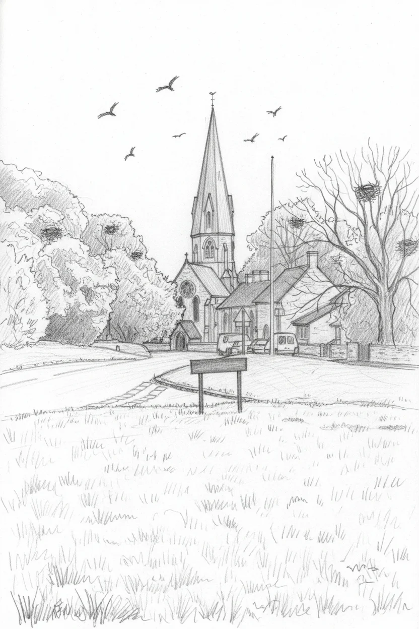
Almost sickly sweet — a bizarre, sharp smell of fertiliser or manure coming from somewhere in the fields. The ploughing looks recent. And then Leafield church spire comes into view around the corner, rising above the trees like a finger pointing at the clouds.
St Michael and All Angels, Leafield
Leafield — the name means simply the field, from the French definite article and the Old English feld, a clearing hacked out of the ancient forest. It sits at six hundred and thirty-five feet above sea level, the highest village in this part of the Cotswolds, historically so isolated by surrounding Wychwood that it was a remote forest settlement well into the Victorian era. The church of St Michael and All Angels was designed by Sir George Gilbert Scott and built in 1860, its octagonal tower and spire originally rising one hundred and forty-five feet — a beacon visible for miles across the surrounding countryside. Within five years the spire had been damaged by severe weather and a smaller, lighter one was erected. In 1934 it was damaged again, probably by lightning, and the top third was shortened. Even diminished, it dominates the skyline. A landmark that has been arguing with the Oxfordshire weather since the day it was built.
Around the church I can hear the crows — or are they rooks? — making themselves heard with their harsh, repetitive calls. I can see their nests up in the trees, great untidy bundles of sticks swaying in the breeze. I think my dad used to say: a crow in a crowd is a rook, a rook on its own is a crow. The saying is old country wisdom, based on behaviour rather than plumage. Rooks are the sociable ones, feeding together on earthworms in ploughed fields, nesting in noisy colonies called rookeries. Carrion crows are the loners, territorial and self-sufficient, more likely to be seen picking at a carcass on the verge than flocking in a field. Looking up at these nests, these are rooks. The evidence is in the community.
A fast descent from Leafield. Wychwood Forest ahead of me — or what remains of it. Sadly a private forest these days, not open for exploring. Once it was a royal hunting forest, stretching across much of west Oxfordshire, ancient and vast. The name comes from the Old English Hwicce, the Saxon tribe who held this territory. By the time of the Domesday Book it was already a royal preserve, and it survived in fragments until the nineteenth century when the enclosures broke it up. What is left is mostly within Cornbury Park, locked behind a private gate that kills the daydream of wandering off into the trees.
◊
III. The Private Kingdom
From the road, the forest is tantalisingly tidy. Trees managed to give each other space, grass growing between them instead of undergrowth — not a wilderness but a parkland, curated for centuries. The Cornbury Park private gate sign puts an end to any hope of closer inspection. I have to content myself with the primroses. They are dotted all across the forest floor, pale yellow against the dark leaf litter, the first real declaration of spring in what has been a reluctant April.
When I worked at Torchbox, we were given special permission to run around Cornbury Park. They still open it for occasional races, but that was an extraordinary opportunity — literally running through the deer, round the back of the house, sometimes seeing a light aircraft taxiing on the tiny strip. Cornbury has been a deer park since at least the fourteenth century — the Close Rolls of 1337 record an order to build a stone wall about Cornbury Park and two deer leaps, one-way jumps that allowed deer in but not out. Charles I gave it to Henry Danvers in 1642; Edward Hyde, the first Earl of Clarendon and Lord Chancellor of England, made it his seat in 1661. The deer are still there — farmed or kept within the park, beautiful creatures grazing among the oaks. I am looking for their wild cousins this morning, but it has been light for a few hours and they have probably had time to graze and retreat.
On my left, a footpath leads up to a place called Stag Plain — the camera walk, as our children know it, named for a camera that was lost here years ago and a reward sign advertising its return. We never did spot it and claim the money. On my right, the one public footpath that bisects Cornbury Park, a straight line through to Finstock. A lovely walk but no options for detouring — there and back, the estate allowing a single corridor of access through its private kingdom.
The yellow of the rapeseed oil on my left as we continue to climb. This has been up and down a bit before we hit the Evenlode valley. I see a hare — those long ears, those strong back legs. Such an incredible creature, bounding across the field and disappearing. A proper wild mammal at last.
We leave the Charlbury road, bypassing the town today, and head for Chadlington. The wind is blowing quite hard from my left now — definitely southwest, which is going to hurt later. A couple of Canada geese fly overhead. We begin to drop into the valley again.
◊
IV. A Proper Village
Chadlington is what I think of as a proper village. It is liveable. We are in the middle of nowhere here, really, but it has got basic little shops. As I cycle past I can see a meat counter — you can buy fresh meat here, you can get what you need. The village shop, Chadlington Quality Foods, is actually community-owned — around fifty villagers put money in to keep it open back in 2001, buying shares in their own provisions. There is a butcher, Slatters, and Café de la Post where the old post office used to be. So many villages out here are really just houses. I feel it must rip the heart out of community and make it so hard for anything to grow if you do not have a pub, a shop, and a place of worship.
The sun has come out and there is a shadow on the ground, just about. Still repaying interest on the altitude debt, earned by dropping down to the river valley. The interest rate is quite painful.
And then — signs ahead in a familiar font. It looks a lot like the font used by Jeremy Clarkson. I have unintentionally brought myself to Diddly Squat, I think. Half past nine on Good Friday morning and a crowd of people are already standing in a car park. People in high-vis jackets waving traffic. This is the edge of Chipping Norton. Everyone is turning in to see Jeremy. I cycle on.
Chipping Norton is another mile and a half, so not there yet. This is our most northerly point today. I think we are going to be turning into the wind for the next thirteen miles of the journey.
Coming into Chipping Norton proper now. I know where I am — that is the road to Charlbury which I would normally be driving on. There is a maternity hall here, used to be a maternity ward. Rachel came here with both of our boys.
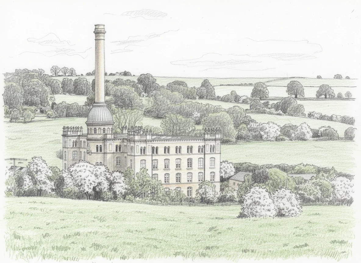
Bliss Mill, Chipping Norton
To my right, in the valley just before the town, sits one of the most extraordinary industrial buildings in the Cotswolds. A small lake in the foreground, and rising behind it a massive structure with what looks like a church spire — except it is a chimney. This is Bliss Mill, built in 1872 by George Woodhouse, a Lancashire mill architect who was asked by William Bliss to design a tweed mill worthy of a country house. Woodhouse obliged with an Italianate masterpiece in honey-coloured Cotswold stone, topped with a Tuscan campanile that conceals the factory chimney — a hundred and sixty-five feet tall, domed and ornamented, a piece of industrial vanity that somehow works. The mill produced tweed until 1980 — at its peak, twenty-five thousand yards a week — and was converted to apartments in the early nineties. The mill pond below it catches the light even on an overcast morning. It is the kind of building that makes you stop pedalling and just look.
Definite headwind now. I guess with a circular ride you are always going to get a headwind at some point. Better at this point in the journey than at the very end. I am having to drop gears to fight the wind, undulating through what should be flat ground.
◊
V. The Altitude Account
Coming into the shelter of the hill above Churchill. Which makes me wonder whether Churchill and Leafield had a wager many years ago and swapped their names — because Leafield is actually a church on a hill, and Churchill seems to have more fields. I like the idea of two villages losing a bet and being stuck with each other’s names for a thousand years. The real etymology is less fun: Churchill appears in the Domesday Book as Cercelle, and scholars think it may come not from cirice hyll — church hill — but from the older Brythonic crūc, meaning a barrow or mound. There is indeed a barrow near the hilltop. The church came later. The hill was already named for the dead.
Churchill also has a very good pub in the Chequers, which I am regretfully cycling past. And a fine church as well, splendid against the grey sky.
Up and over the other side, headwind all the way, and past a building that stops me thinking about the wind entirely. The entrance says OX, with three ears of barley standing upright. Through the gates I can see an extraordinary blend of architecture — old Cotswold stone barns alongside a radically modern oval structure, all glass at one end. This is Daylesford, Lord and Lady Bamford’s organic farm estate. The three barley ears are their logo — the estate has been organic since 1975, one of the pioneers of the movement, and the farm shop that opened in 2002 became a destination in its own right. But it is the architecture that catches the eye from the road: the bold juxtaposition of ancient stone and contemporary glass, traditional agricultural buildings repurposed and extended with something that feels genuinely ambitious. Find the architect, I think. That deserves commentary.
One mile from Kingham. Smooth roads but getting hammered by this wind. Only benefit is that the uphills give you slight shelter, but no benefit on the downhills at all. I am overtaken by a proper cyclist — proper kit, proper speed — who makes me feel suitably pedestrian.
Crossing the railway line again. Kingham station is just to my north — a quiet Cotswold halt now, but during the war a seven-line railway siding was thrown up here for storing munitions ahead of D-Day. Hard to picture on a drizzly Friday morning.
Now entering Bledington. I am well off my beaten path here, I do not know these towns and villages well. Over a river — the Evenlode, which forms the county boundary. Until the 1890s it was still called the River Blade on Ordnance Survey maps, and that older name survives in the village of Bladon, where Winston Churchill is buried. Bledington itself takes its name from the river — Bladinton, the settlement on the Blade. A sign welcomes me into Gloucestershire. Daffodils lining the verge, just about hanging on. Past an old mill house — the Domesday Book records a mill here in 1086, and there was a miller in Bledington until 1935 — and the river spilling out under another bridge. Gorgeous.
Steep banks giving me a little shelter at the price of reduced visibility. A fair trade. Old cottages with leaded windows, and on one wall a pair of iron crosses — pattress plates, though I do not know the name at the time. My dad would have known. They are structural ties, wrought-iron clamps of Flemish origin, connected to rods that run through the building and anchor the outer walls to the inner beams. They stop old stone houses from slowly pulling themselves apart. Structural medicine, applied centuries ago, still holding.
The hedgerows here are covered in tiny white flowers — blackthorn, not hawthorn, though I do not know it at the time. Blackthorn blooms in March and April on bare dark branches, before its leaves appear. Hawthorn waits until May, flowering on branches already green. If you see white blossom on naked wood in early spring, it is the sloe berry’s tree, not the may. Through the gaps, the rapeseed is bright yellow — a crop that was virtually unheard of on English farmland before 1973, when European grants after joining the Common Market made it attractive. It is now the third most important UK crop after wheat and barley. The Cotswold spring palette has been rewritten within a single generation.
My legs are feeling it. Well over halfway. This could be a hard second half.
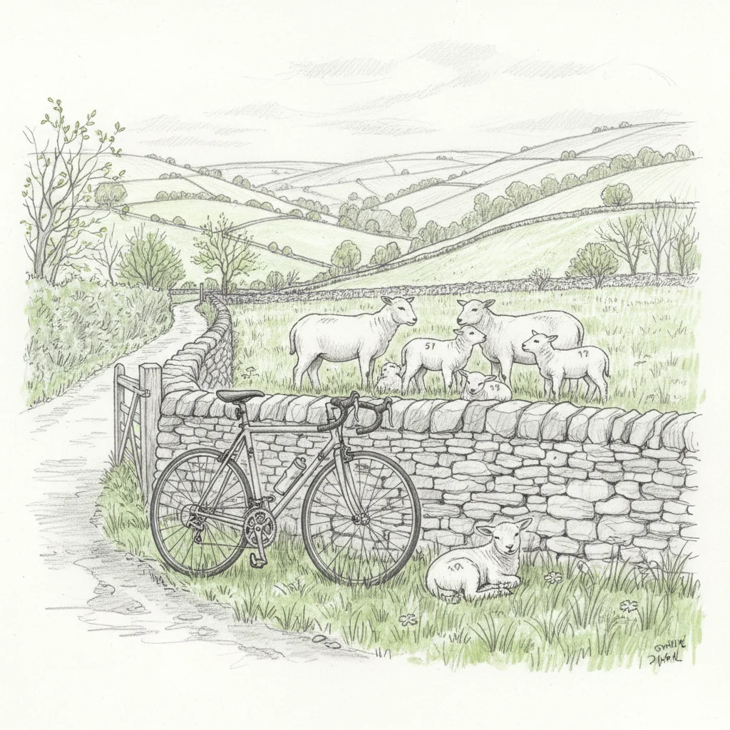
And then — baby lambs.
Lambing season on the climb to Bould
I stop, partly because I am on a hill and any excuse will do, and partly because I want a picture. There are four at first. No, far more than four. A farmer has been out and numbered them — little painted marks on the fleece. We will leave them in peace. I get back to my hill. Mammal count remains at two, not counting domesticated mammals.
Amazing how even sixty seconds off the bike gives the legs a tiny rest, a chance for the muscles to reset.
◊
VI. Old Friends
Into Idbury — a little tiny church with a squat steeple, primroses galore in a central triangle of green, a bleak large manor house on the corner with little lead-paned windows. It is an odd combination: delicate flowers and stern architecture. The manor was built in 1570, and in 1922 it was bought by J.W. Robertson Scott, a journalist and rural reformer who five years later founded The Countryman magazine in its upper rooms — turning this small stone house on a back lane into the editorial headquarters of one of England’s most influential rural publications. The primroses do not know this, but they suit the setting.
The hedges protect me from the worst of the wind as I climb through towards Church Westcote, long slow ascents made bearable by the shelter. And then the hedges drop away and the view opens — a beautiful valley off to my right, miles of visibility, a range of hills in the distance that I cannot name.
I have joined the main road from Burford to Stow, and I know where I am. I recognise these place names from signs I have whizzed past in a car, heading for places I had never actually been to. That is the thing about cycling — you notice the detail. The small turnings, the signposts to hamlets, the texture of the landscape between the places you know.
Signs to the Risingtons — Upper, Little, Great. The RAF base at Little Rissington opened in 1938, and during the war it trained five thousand four hundred and forty-four pilots — seven hundred and five of whom received awards for gallantry, including four Victoria Crosses. From 1946 it became home to the Central Flying School, where over six thousand flying instructors learned their craft in the three decades that followed. The Red Arrows were born here, or at least their predecessors were — aerobatics teams training above these quiet fields. The married quarters were sold off in 1996 and became the village of Upper Rissington, a community literally built on a runway.
The Risingtons mean something personal too. The first time I came out here was 2007 — meeting a couple of guys running a startup called Historic Futures, a supply-chain traceability company, at their office on the old base. I was at Amazon at the time, looking for something closer to home. We connected, but at that point I was a software manager, my coding had gone stale, and they did not need a manager — they were still tiny. But it was a relationship that would last. In 2014 I ended up contracting with Historic Futures at their later office in the woodyard at Coombe, building friendships with Tim Wilson and Simon Warwick and the team. Little did I know that my path with Tim would keep crossing through the years.
And Jon Hicks — the designer who rendered the Firefox logo into its final iconic form, and who also designed logos for Thunderbird and MailChimp — ran his studio from a converted building on the same old RAF base. He and John Oxton podcasted from there, a web-geek version of Gardeners’ Question Time broadcast from ex-military quarters in the Cotswold countryside. He had studied wildlife illustration before becoming a designer, and he lives in Witney. Small world, small roads.
It is ten twenty-seven. I am stopped at temporary traffic lights. Twenty-two miles done, some light rain.
Rather rashly, I have spent all of my altitude savings in one big spending spree. A lovely long descent, but there has been a bit of rain to make the road greasy and these slick tyres felt dicey. I had to hold back. And now I feel overdrawn in the altitude account — all the altitude I had banked, spent on the descent, and the interest accruing on every uphill that follows. I am very much down in the flats of the river valley.
Down through Naunton and Clapton-on-the-Hill, dropping into the valley, and into Bourton-on-the-Water — the settlement beside the camp, from the Saxon burh-ton, and the camp in question was real. Salmonsbury Camp, just east of the village, was a massive Iron Age fortified settlement and trading hub for the Dobunni tribe, with evidence of occupation stretching back to the Neolithic. The Windrush was intentionally widened through the village centre in the eighteenth century to create the shallow, picturesque waterbed that gives Bourton its nickname — the Venice of the Cotswolds. A steady stream of people heading towards Birdland. I decline the opportunity to cycle through the ford and take the bridge. Call me cautious, but I do not want two hours of wet feet. If we were by the sea I would call it a sea fret — a kind of light mist, water sitting in the air. Bourton is behind me in less than a minute, people everywhere, and then I am out clear and through to deserted lanes again.
And onto a steep bit of hill. Sixty-seven metres in half a mile. This is perhaps more of a gradient I might expect when I hit the hills of Burundi. I am desperately looking for a lower gear that does not exist. I try to zigzag right, to take a little out of the gradient. Repaying the altitude credit card. It is hurting.
◊
VII. Tea by the Pint
Back up onto the ridge. Bourton dropping away behind me. I am picking up that wind again, but this time blowing from my right, which says I am making a turn round the clock. Must be time to head south. South always feels like it ought to be downhill.
I have just crossed the Monarch’s Way — the same long-distance path we crossed on the last ride, tracing Charles II’s desperate flight after Worcester. Familiar territory now — Sherborne and Farmington signed off to my left. A goldfinch flies diagonally with me for a moment — that amazing yellowy-gold chest adding a bit of colour to an otherwise dreary day. More lambs out here. A squirrel. Mammal number three.
A very long, gently sloping downhill. Able to make the full most of it without any braking. Looking out on a classic kind of green, sloping farmland hillside — a couple of trees dotted across it towards a sprawling honey-coloured farmhouse. Stunning.
I am picking up my route from last Saturday. A sign to Turkdean on my right, Farmington ahead — familiar ground now. That was hill twelve of fifteen. We are about thirty miles in, sixty per cent of today’s ride. The human battery feels about eighty per cent used. The maths is not encouraging.
Northleach one and a half miles. Come on. We bypass the town centre this time, head and legs remembering the steepness of the climb coming out. Stand and pump to try and clear it. Slower than walking, but we are not walking. Although we have still got a long way to go. First cattle of the day — browns and blacks and one creamy white. A couple of male pheasants are cockfighting right by the side of the road, and barely glance at me as I pass.
The wind begins to cooperate past Aldsworth. Starting to feel it on my back rather than my side, which is very welcome. Back on the smooth straight road from Cirencester to Burford — head down, chew up the miles. That extra little boost from the wind, very welcome to an achy body. Thirty-six miles. About fourteen to go. Wishing it were four.
You just have to decide to keep going.
It is not the legs any more. It is actually more about the willpower. Certainly long-distance running is more in the head than the legs — you have got to have the legs at some level, and then it just becomes mental.
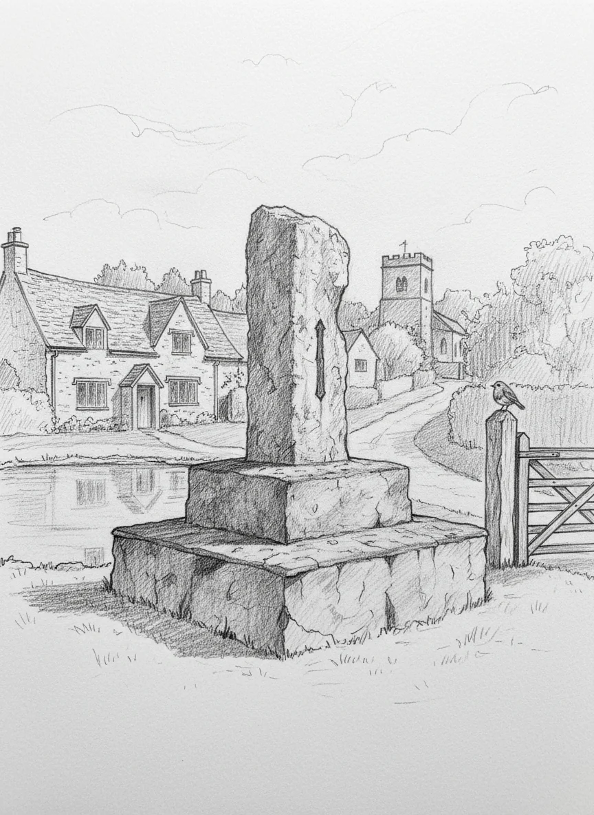
The war memorial at Westwell
Past an enormous gate and a circular wall near Westwell. A stunning little village with a big pond in the centre and a stone monument — the war memorial, a monolithic upright slab of stone on a raised plinth. English Heritage calls it unusual, of cyclopean proportions. It was put up by Stretta Aimée Holland of Westwell Manor to commemorate her two brothers killed in the First World War. Set into the stone is a numeral from the clock face of the Cloth Hall at Ypres. A reminder that grief can be built into stone and still stand a hundred years later.
The D’Arcy Dalton Way crosses here. A place to explore one day. Right now I need to get on. I want some lunch. I want something hot to drink. And I want my legs to stop going round and round and round.
A robin sits right in the middle of a gatepost, watching the world go by. Which on this road is not a lot. One older, middle-aged man, dragging himself home.
A muntjac — a tiny deer, not much bigger than a Labrador, walking down the road just ahead of me. It sees me, startles, and leaps one and a half metres straight up through a gap in the dry stone wall. Gone. Muntjac are immigrants, like the larch trees I passed hours ago — descendants of escapees from Woburn Abbey in the 1920s, now established across most of England. Also known as the barking deer, and built, apparently, more like a cat than a deer — able to squeeze and jump through gaps that look far too small for them. That wall did not slow it down for a second.
Gorgeous barn conversions — holiday cottages, by the look of them. The A40 looms. I know roughly where I am. Lovely to open up some new roads. Someone has treated their child to an amazing wooden fort in the garden. Then Burford — crossing the A40, which is never fun on a bicycle. Cycling past the garden centre, probably rammed on Good Friday. I am not sure dirty, sweaty cyclists are welcome in the Burford café.
After all the country lanes and history, I am now on the edge of Carterton — a town that barely existed before 1894, when William Carter’s Homesteads Limited sold plots here — and one of their newest housing developments. Silky smooth tarmac, short grass, tidy gardens. It is a bit odd. After centuries of honey stone and crooked walls, the sudden appearance of a modern housing estate feels like switching channels mid-programme. A real maze of intersecting roads, my satnav threading me through.
Back out onto the old Kilkenny Lane. New housing on the edge of the Brize Norton air force base — a little square, almost like a Monopoly board, stuck right up next to a tower with a rotating radar dish on the top. On my left, old Brize Norton and the Mason’s Arms. Probably a lovely place to live before they stuck a great big airbase next to it. Probably still is.
The wind that was struggling earlier, dripping off in effort, is repaying me in spades. My legs are shot. My shoulder is killing me. Thighs just burning. But the wind is helping me hold a not-embarrassing pace. Two and a half miles to go.
A small detour to add the triangle that rounds me up to fifty. Silly — playing with round numbers — but as I was saying earlier, it is all in the head when it gets to endurance stuff, and right now I need that number. My running route in reverse. Hello Witney. It is nice to see you.
The counter rolls over to fifty and I cycle up the drive. Done.
When I was in Snowdonia, John Cox took us to a café on a very wet day. We had aborted a climb of Tryfan because of the weather — I was gutted, I really wanted to do it, but he made a wise call. And this café served tea by the pint. The best pint I have ever had. What I would give for one of those right now.
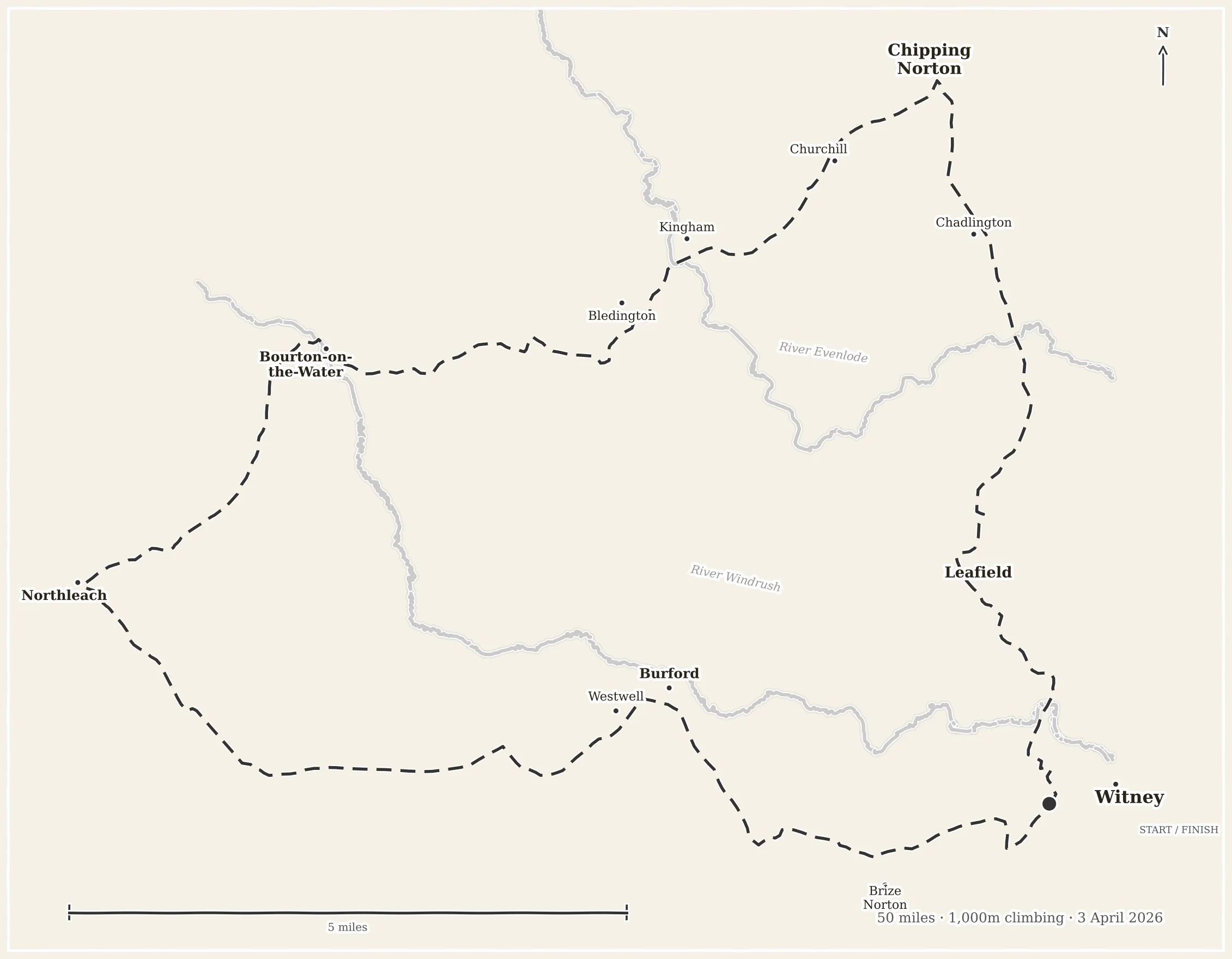
Fifty miles. Seventeen hills. A thousand metres of climbing. One hare, one muntjac, one dead rat, three squirrels, a goldfinch, a robin, and more lambs than I could count. One Jeremy Clarkson crowd, one Ypres clock numeral, one Tuscan chimney disguised as a church spire, and a pair of legs that will not forgive me until Tuesday.